A first version of this idea existed already, built on Google Earth Engine — but Earth Engine only ships Python and JavaScript bindings, and it's a research compute platform, not an imagery API, which made it slow and awkward to build a real product on. Beyond that starting point: a smaller regenerative farm has no in-house GIS or remote-sensing expertise, but still needs to know which part of which field is stressed, this week, without walking every hectare.
— Case study 06
Flora
An operations console for regenerative farming, built on a real satellite pipeline

project overview
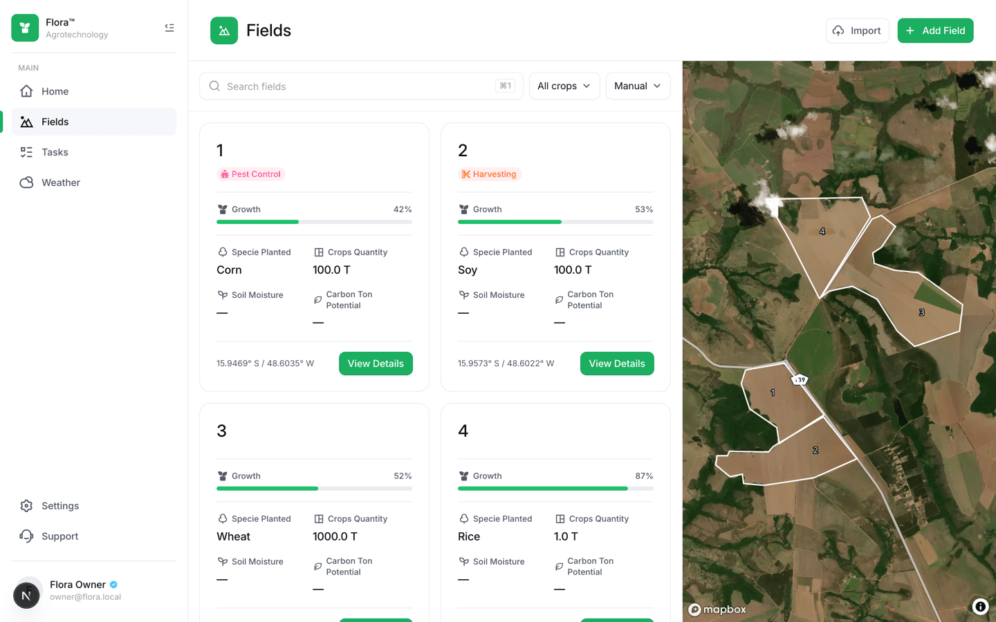
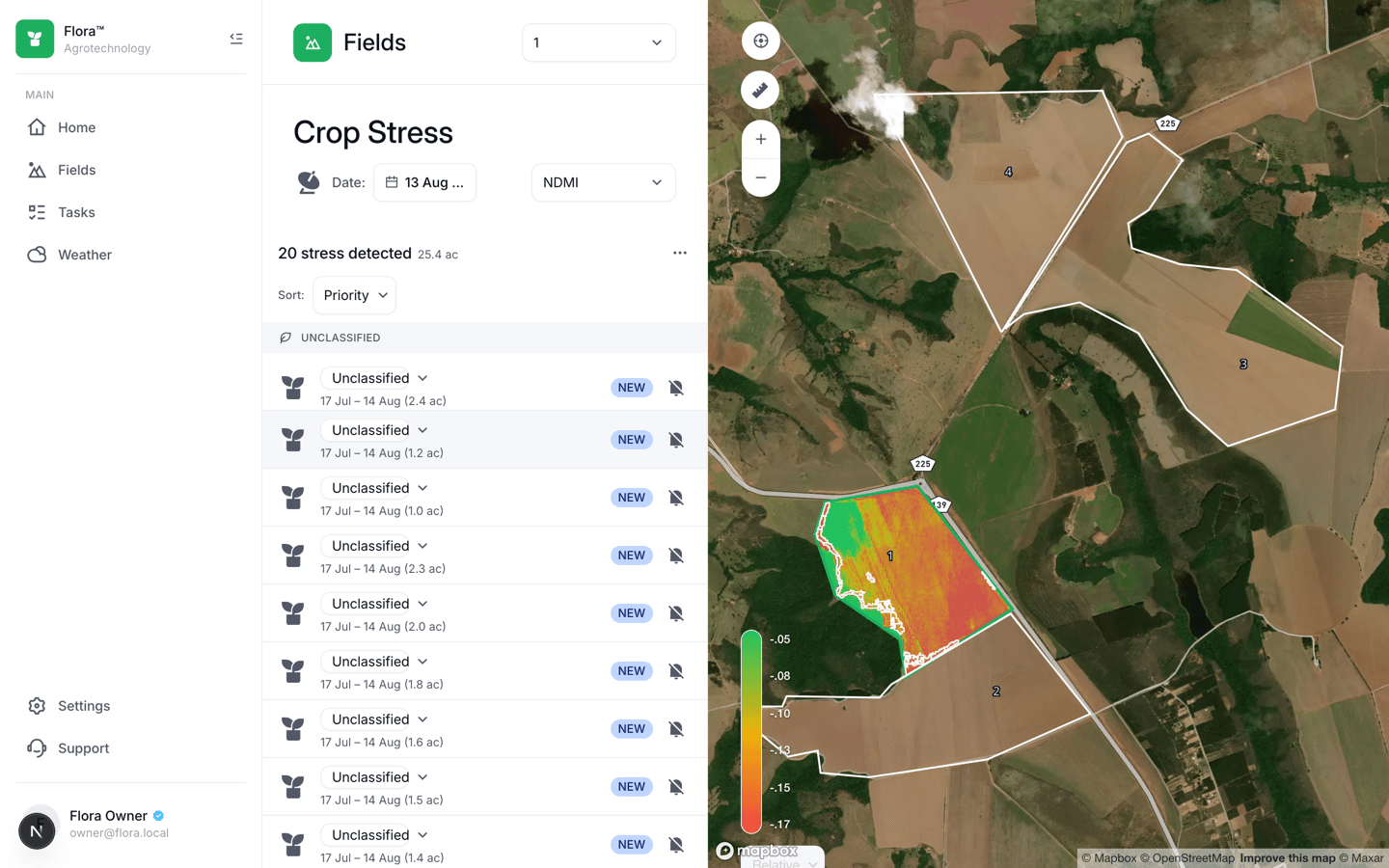
A farm operations console where a scheduled worker — never the app itself — asks satellites for ten different plant-health readings per field, so a farmer opens a map and sees exactly which corner of which field is stressed, backed by real Sentinel-2 imagery.
shipped outcome
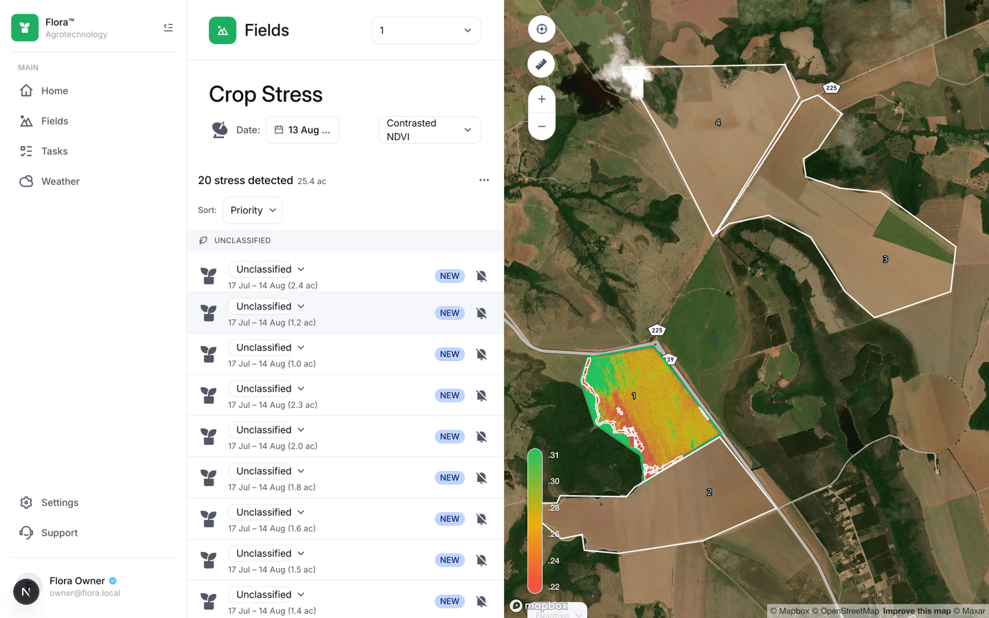
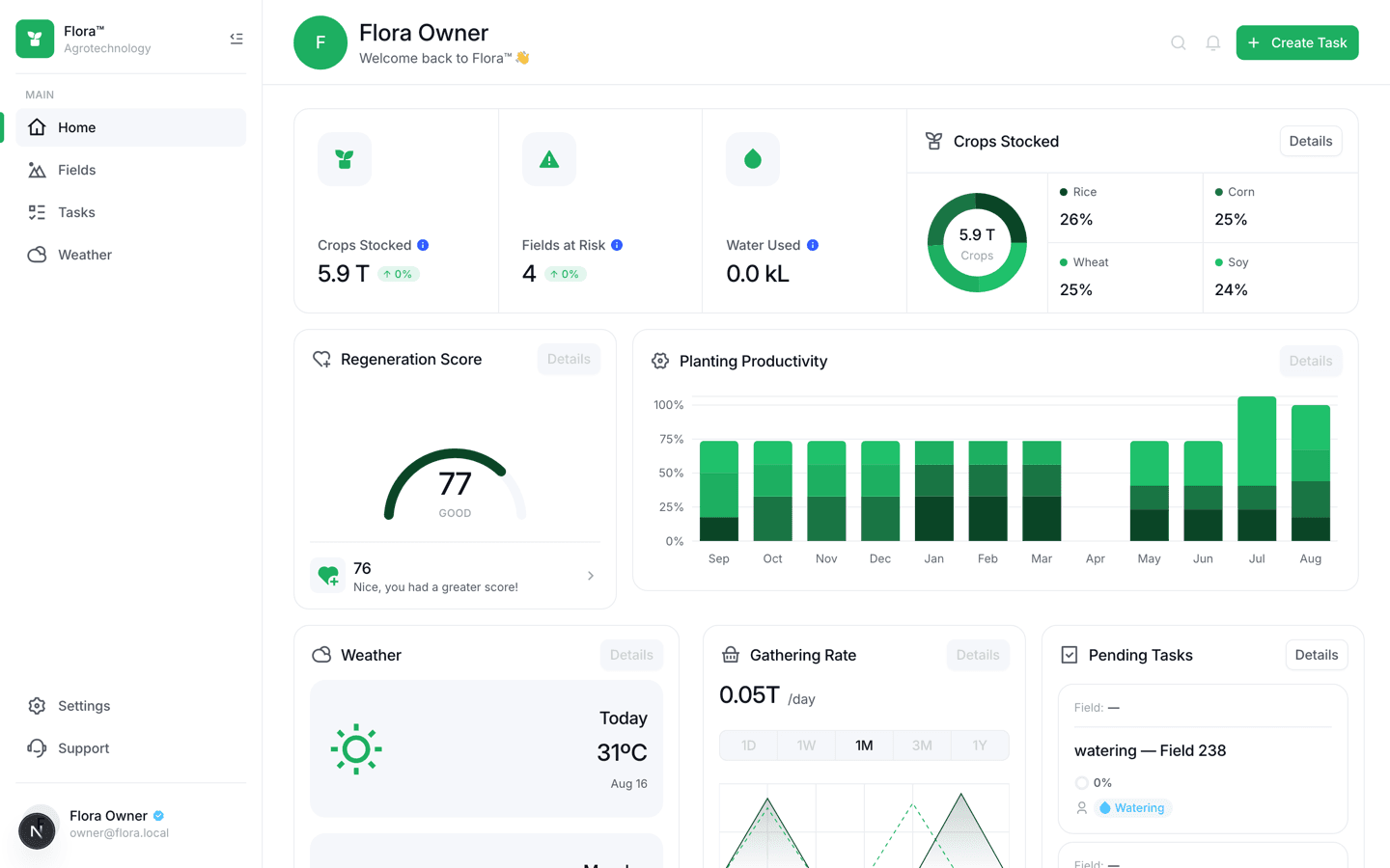
A working spine — register a field, watch a real stress zone appear from real Sentinel-2 data, act on it as a task — plus a home dashboard scored by a sourced formula, a ten-index spectral switcher, and a weather screen. Several of the sharpest bugs never showed up in a code review: they only appeared once a manual refresh ran against a real Copernicus account and a real field boundary, and got fixed the same way — by looking at what actually rendered.
- Role
- Full-stack product engineering
- Timeline
- Ongoing
- Year
- 2026
- Team
- Solo delivery
The whole system is rebuilt around one invariant: no request ever calls the satellite provider. A NestJS worker polls Copernicus's Data Space Ecosystem on a schedule, decodes the returned imagery, computes ten spectral indices from a single Process API call, and writes pre-rendered PNGs to object storage plus rows to Postgres. The API — a separate NestJS service — only ever reads Postgres and Redis, a split enforced by an actual test. Every tenant table sits behind PostGIS row-level security and a repository-level filter, checked by a cross-tenant suite that asserts a 404, never a 403, on another org's data.
A working spine — register a field, watch a real stress zone appear from real Sentinel-2 data, act on it as a task — plus a home dashboard scored by a sourced formula, a ten-index spectral switcher, and a weather screen. Several of the sharpest bugs never showed up in a code review: they only appeared once a manual refresh ran against a real Copernicus account and a real field boundary, and got fixed the same way — by looking at what actually rendered.
— Interface evidence
The product, not a placeholder
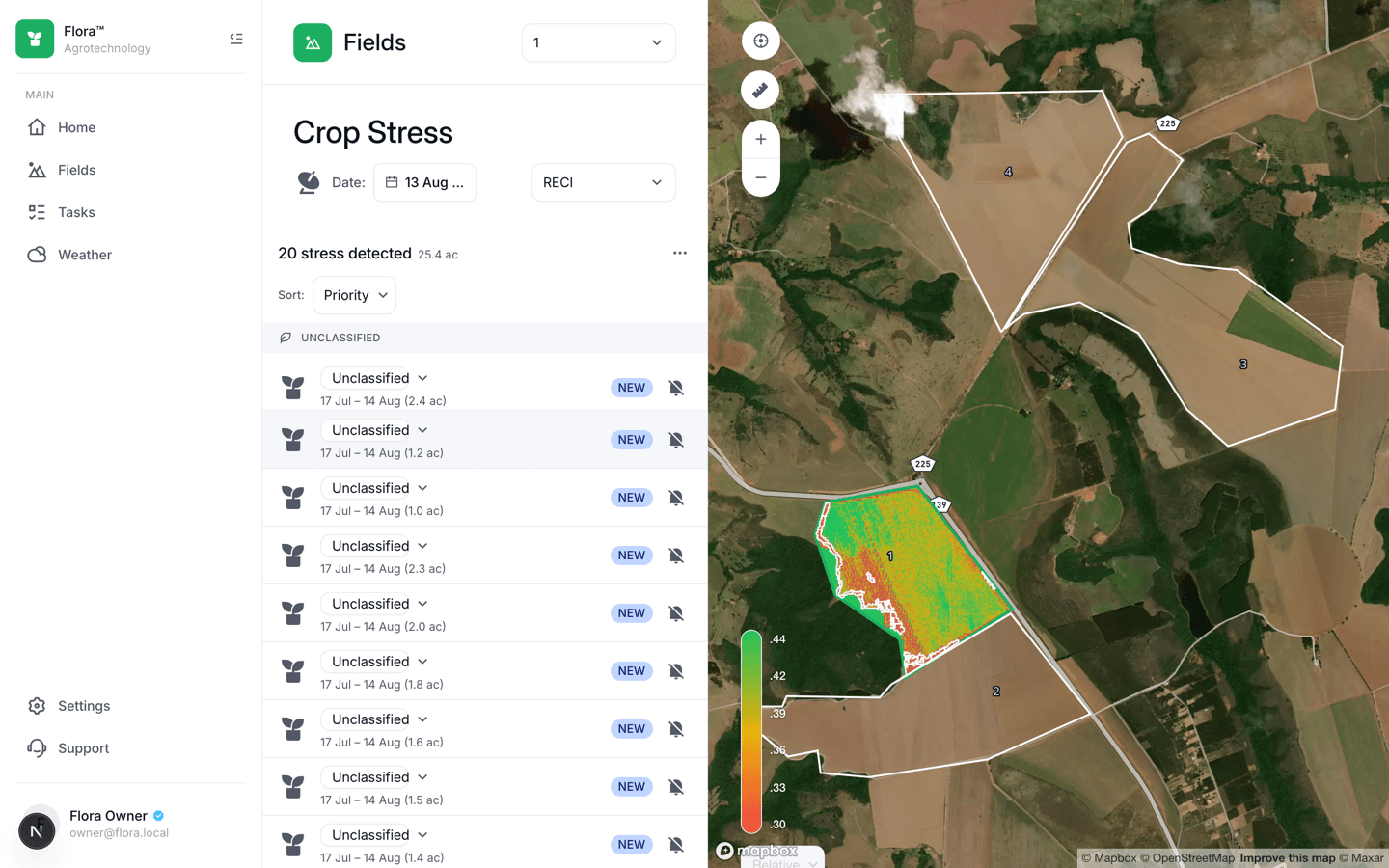
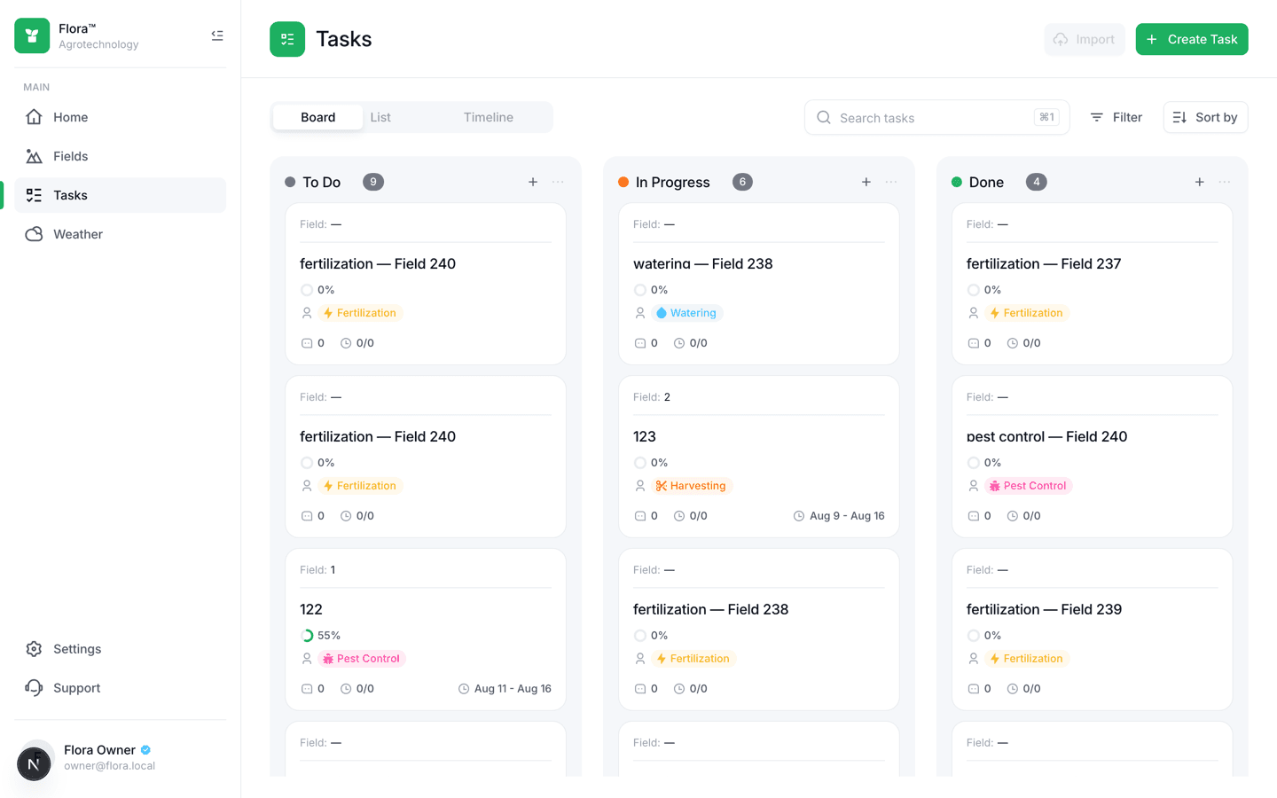
These are the verified interface captures from the project build. Scroll inside taller frames to inspect each complete page.


— Delivery process
From operating constraint to shipped system
The work is sequenced around risk. Domain rules and failure states come before interface polish; automation arrives before handoff.
Foundations, schema, tenancy
A pnpm/Turborepo monorepo, a Drizzle + PostGIS schema for ten domain tables with composite foreign keys, and identity with RLS enforced twice before any product screen existed.
The spine: Fields → Crop Stress → Tasks
Field CRUD and boundary drawing on a Mapbox map, then the satellite write path (a CDSE HTTP client, a decode-to-PNG raster pipeline, a BullMQ per-field scheduler), then the screen that reads it, and finally a Kanban task board with a real @dnd-kit drag.
Ten spectral indices
Widened the pipeline from one scheduled index to ten in a single Process API call — verified live to cost 4.667 Processing Units against a 4.0 baseline, since output count turns out to be free and only the input bands matter.
Home dashboard and weather
Daily rollups, a Regeneration Score built from AAFC's published agri-environmental performance index instead of an invented composite, and an Open-Meteo weather screen with six instrument cards.
— System architecture
Clear boundaries, explicit responsibilities
Each layer has one job and a narrow contract. That keeps external services replaceable and product behavior testable.
field_01
25.4 ac
15.9469°S / 48.6035°W
stress detected
20 zones
layers / 4.667 pu
Next.js App Router
AlignUI shell, Mapbox map, Recharts — reads only Postgres-backed API endpoints, never a satellite provider directly.
NestJS
A separate service from the web app, reading only Postgres and Redis — enforced by a test, not a convention.
NestJS standalone + BullMQ
The only service allowed to call Sentinel Hub — a scheduled per-field job, not a request handler.
PostgreSQL 16 + PostGIS 3.4
Drizzle ORM with a custom geography type; every tenant table behind RLS and a repository filter, both.
— What shipped
Product capabilities
Ten-index spectral switcher
NDVI, NDRE, EVI, MSAVI, RECI, MCARI, a labelled PRI proxy, NDMI, NDWI, and VSDI, each with its own colour ramp — and an honest disabled state for the ones this pipeline can't produce yet.
Real stress-zone detection
A raster overlay clipped to the field's true polygon boundary via its imagery's own 'no data' class, with grouped detections and a popover wired to real task mutations.
Tenancy enforced twice
Row-level security and a repository filter on every tenant table, checked by a cross-tenant suite asserting a 404, never a 403, against real RLS.
— Engineering pressure
Challenges resolved
A missing header that looked like an auth failure
No `Accept: application/tar` on the Process API request meant Copernicus silently returned a bare TIFF instead of the requested archive, and the parser's own error read exactly like a token problem — only testing against the real, live account surfaced the actual cause.
A masking bug two indices had and eight didn't
Eight of ten spectral indices are NDVI-shaped ratios, where a masked pixel naturally produces `NaN` outside the field boundary. Two indices with no division in their formula evaluated to a real, in-range number instead, painting a rectangle where a field polygon should have been — fixed by masking on the imagery's own 'no data' class instead of a formula side-effect.
A synthetic seed that never clipped to a real boundary
The satellite seed script filled its field's entire bounding-box rectangle with valid pixels, since a synthetic raster has no reason to know the field's real, non-rectangular boundary. Found by looking at a rendered field, not by inspecting the script.
verified project destinations
next transmission
Need a system this deliberate?
Bring the operating problem. We will shape it into a clear product brief and a buildable next step.
Start a project